Astir Marina
Neiheiser Argyros

ARCHITECTS
Neiheiser Argyros
ARCHITECTURAL DESIGN OF BUILDINGS
Αeter Architects
LANDSCAPE
Neiheiser Argyros
PUBLIC REALM DESIGNER
Neiheiser Argyros
SOFTSCAPE CONSULTANT
Srla Simon Rackham
ENVIRONMENTAL
Marnet S.a.
MEP DESIGN
Team Consulting Engineers
GEOTECHNICAL
Edafos Engineering Consultants S.a.
STRUCTURAL DESIGN
Ττα S.a.
TRAFFIC DESIGN
Dromos Consulting
LIGHTING DESIGN
Ck.design.lighting
PLANNING CONSULTANT
Periklis Konstantinidis
PROJECT MANAGER
Hill International
MAIN CONTRACTOR
Tekal
CLIENT
Astir Marina
NEIHEISER ARGYROS TEAM
Ryan Neiheiser, Xristina Argyros, George Foufas, Tasos Theodorakakis, Eleni Vagianou, Iason Ntounis, Alkisti Michelatou, Andreas Anagnostopoulos, Pelagia Spyridonidou
PRELIMINARY MASTERPLAN OF MARINA LAND ZONE
Kse Studio
TYPE
Marina Landscape & Public Realm
OWNER
Astir Marina Vouliagmenis S.a.
HYDRAULIC DESIGN
Dromos Consulting
PHOTOGRAPHS
Giorgos Sfakianakis, Lorenzo Zandri
MARINE
Marnet S.a.
AREA
60000 M²
YEAR
2024
LOCATION
Athina, Greece
CATEGORY
Public Space, Landscape Architecture, Transportation

The site for the Astir Marina is the Vouliagmeni Peninsula, a lush pine forest along the south coast of Athens, Greece. However, since it's a marina, the actual site is also the new engineered ground that is being constructed in the sea. The concept for the project emerges out of the unique challenge of designing a landscape where there is currently no land.
One way of thinking about this lack of land is that it's a blank site – a void – a tabula rasa. But of course this isn't the case. The sea makes invisible the complex and dynamic ecosystems of the sea bed which is continuous with the visible ground.


We started by looking at ways of representing this sea landscape; the nautical charts and maps that use elevation marks, contours, wind vectors, gradients of color, and hatches to represent the territory that is both above and below the water line. We were particularly inspired by the aesthetic of topographic contours, traces of the ground projected onto a flat 2d surface.
We looked back at the geographic history of the site, using old military aerial scans from World War II, in order to discover the original or "natural" shape of the ground, with its beaches, and coves, and islands.


We found this prehistory really exciting and wanted to try and tell the geologic story of this site in our design. We therefore overlayed the historic contours with the marina outline generated by the marine engineers for the project.
This marina outline shape is obviously a response to different forces – the logistics of yacht movement, and the economies of mooring spaces, along with the need to resist the winds and waves. We were interested in the overlap of the history of the site with the new logics, so found the literal projection of the historic contours onto the new flat infill a compelling new image for the project.


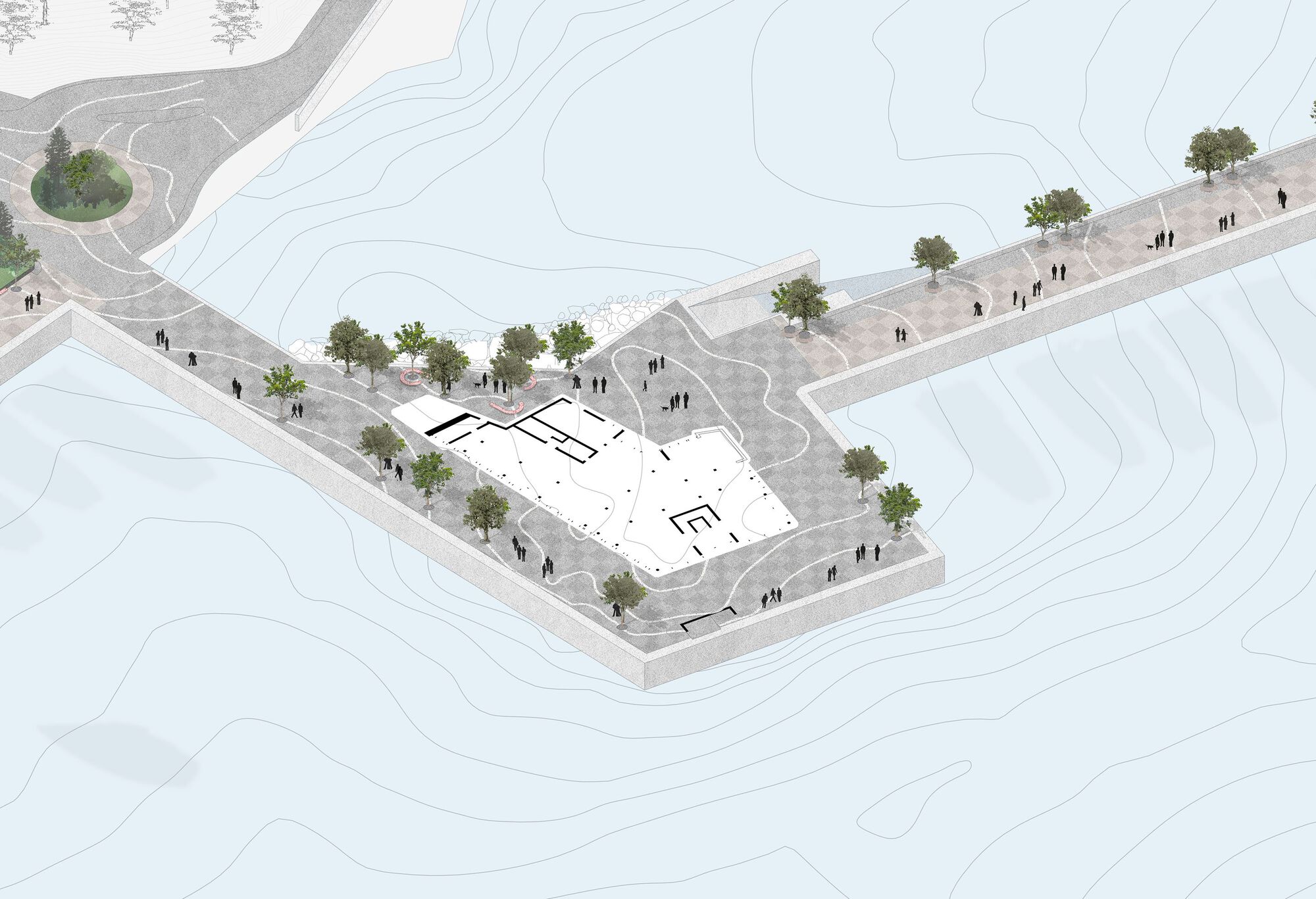
In addition to these contours, we overlayed a new 2m local grid (oriented to the central marina basin) with the global grid. And next we created our own green islands on the site, landscaping barriers between the water's edge and the cars on the site; but shaped like tiny new artificial islands.
In this way the landscape design is a giant map of the history and current pressure on the site, literally drawn into the hardscape of the new marina. Like the map in Borges' short story, On the Exactitude of Science, the project is a map that is as accurate as the reality it represents. The map is the territory.


Of course there are many other motivations for the project; the history of the midcentury modern resorts adjacent to the site, along with the ancient history, the material logics, the local flora and fauna. But the project is also inherently global in its ambitions… to be a worldclass marina, and a shopping destination with global brands, etc.
The Astir Marina project is conceived as an overlay of different systems – the graphic inspiration of nautical maps, the materiality of the site, the local and the global creating a productive friction.


THE ORIENTING GRID
Rotated 23 degrees off of global north, but oriented to the central basin, the orienting grid spreads equally across the entire site, aligning with the heart of the project, but clashing with the geometry of the pier further out.
In this way the grid helps remind visitors of their location relative to that local grid of the central basin, no matter where they are on the site.


Although the grid spreads across the entire site, we created a hierarchy of materials to realize the grid.
A mix of honed, flamed, bush hammered and sand blasted basalt stone around the primary retail and restaurant buildings, rough-cut Portuguese pavers at the pedestrian promenade along the waterfront, and two-colored asphalt at all the roads and back-of-house areas.


As much as possible we created shared surfaces for cars and pedestrians, minimizing the use of kerbs, instead creating pedestrian oriented spaces where cars feel compelled to slow down.
THE HISTORIC TOPOGRAPHIC CONTOURS
The topographic contours represent the historic seabed that existed before the marina was built. Each line corresponds to a different elevation of the historic ground, like a 1:1 map of the territory that used to exist on the site.


Inspired by Pikionis, we used marble offcuts from nearby quarries to make the contours. We inlayed the various shapes of marble in a playful arrangement within the 300mm wide contours. We really liked the graphic relationship between the organic contours and the ordered grid that they pass through.
On the main plaza the contours are polished smooth, like a terrazzo. In the rest of the landscape they are left more rough, with the marble offcuts casting small shadows to accentuate their form.


THE GREEN ISLANDS
When we started the project, we collected references of the state of marina design. And we were struck by how harsh of an environment they typically are, especially in the space directly behind the boats… more infrastructural than public realm.
A mostly concrete space for cars and power connections. Instead of this, for the new Astir Marina, we proposed moving the primary car locations to the back of the site, behind a green buffer, in the form of a slightly surreal planted mound, or island.


And tried to create a more pleasant public realm at the water's edge… a shared space for limited car drop-off, but primarily for pedestrian walking…. With benches, shade, and acoustic and visual separation from the parking areas.
Each island has a slightly different geometry, a unique identity… and the space between these islands become passages to slip between the water's edge promenade and the back of house area at the rear of the site.
The islands were detailed in a way so that they seem to be emerging from below the ground, not sitting on top of it… bubbling up from below.


It was important to us that these islands, unlike the graphic surfaces of the grid and contorus, be three-dimensional.
They are exaggerated mounds that create a new landscape… a new topography.This isn't just the neutral, flat land of a new marina pontoon… There is life here, there is nature, however artificial.
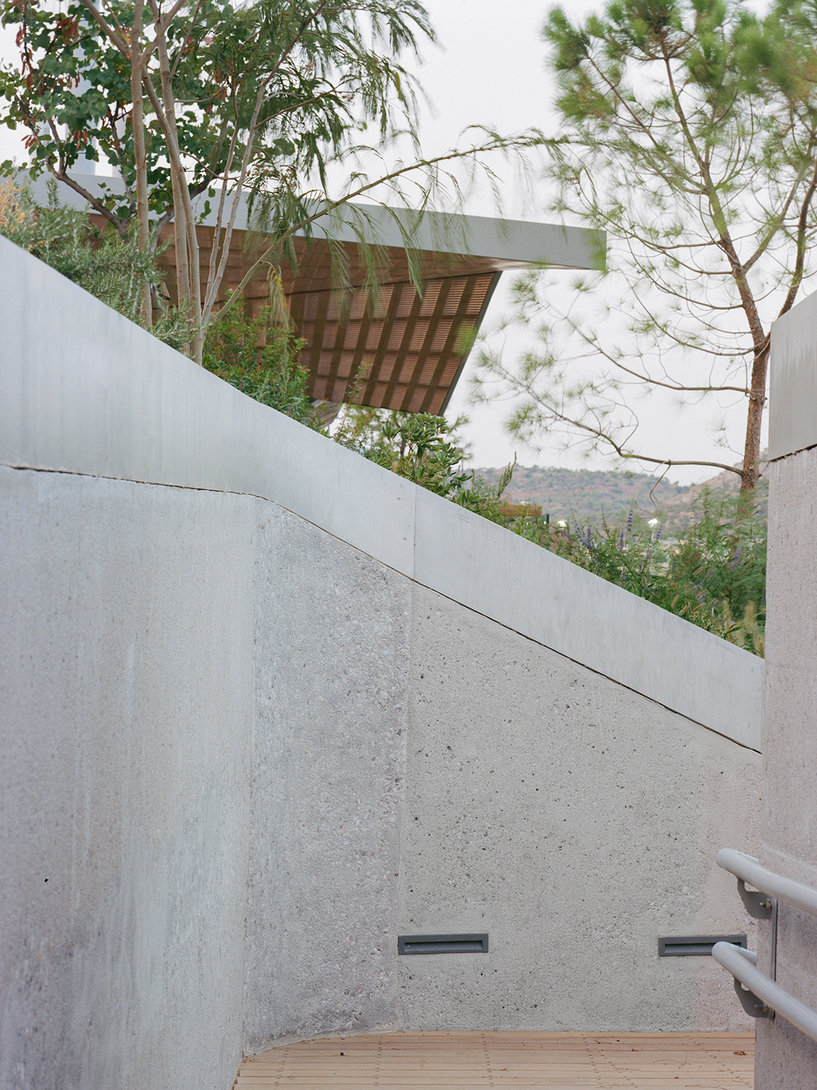
The Retaining Wall + Archaeology Path
At the back of the site, closer to the existing hotel, the natural ground slopes from the road above down to the water's edge, with a 4-6m elevational change.


The new buildings and parking garage are partially cutting into this slope, requiring a new system for shaping, and restraining this natural ground.
Part of the brief was also to design a path that would link the existing Four Seasons hotels through the forest and down the slope to the marina.
Instead of a flat retaining wall, we wanted to created terraces, inhabitable spaces for new and existing plants to flourish.


We looked at the historic agricultural stone walls on the Greek islands as inspiration.
We liked the idea of using gabion walls, in order to avoid the need for concrete or mortar, and to further echo the aesthetic language of grid and contour, now with the grid of the gabion mesh contrasted with the roughness of the natural local stone.
We proposed four different size rocks in the gabions, stratified counterintuitively from smallest at the bottom to largest at the top, which create different sized microenvironments to support different sized local bug and animal life on the slope.